Benghazi, from The Civil War to A Reconstruction Plan
Conversation with the director of the Benghazi Salam Center, Faraj Najem, on Benghazi reconstruction plan, recently approved by the Municipality and presented on June 17.
Benghazi, waterfront overlooking the Al Da'waa al-Islamiya building, in 2014 transformed from its original commercial function into the new Libyan Parliament. Photo Maria Luisa Palumbo
Conversation with the director of the Benghazi Salam Center, Faraj Najem, on Benghazi reconstruction plan, recently approved by the Municipality and presented on June 17.
On the occasion of my field research in Cyrenaica and presentation of my work on the intertwined histories of the agricultural colonization of Sicily and Libya at the Benghazi Salam Center on June 22, I interviewed the director of the center and Professor of Governance at the University of Benghazi Faraj Najem.
I’d like to begin this conversation trying to summarize the most important moments and reasons of the 2014 civil war, and I would like to do so precisely from the spatial location in which we find ourselves, that is, from the point of view of the city of Benghazi, from its representative buildings and urban areas. So, maybe a good starting point could be the Al Da’waa al-Islamiya building, in 2014 transformed from its original commercial function and turned into the new Libyan Parliament. In my understanding of the war, this “adaptive reuse” speaks about a nodal point in the conflict, that is, about Cyrenaica’s request of a spatial division or distribution of the executive and legislative powers between Tripoli and Benghazi, right? Is this division of powers between the two cities the core of Benghazi’s proposal of a federal unity between the two regions? Furthermore, Libya’s 1951 Constitution and 1963 Amended Constitution provided for two capitals, right?
The war basically was ignited by extreme Islamists led by ISIS and another ultra home-grown organisation called Insar Sharia [champions or advocates of Sharia law implementation], in addition to other proxy militias who wished to fulfill the prophesy of having a sharia-based Islamic state. This is, however, contrary to the teachings of Islam that Libyans have enjoyed since the Islamic Arab conquest in the 5th century. The extremists were crushed primarily by the zeal of Cyrenaicans and then the beleaguered Libyan National Army (LNA), who grew by time in strength and extended its supremacy over much of Libya by no less than 70-80%.
As for al-Da’waa al-Islamiya building which was hit badly by those outlawed elements of Islamists, and once was taken over by LNA, and handed back to its rightful owners who rented it to the parliament, and after doing the due maintenance and renovation, to be the constitutional home till they build their own. The previous occupiers whether commercialists or else, they had already established themselves to other places at the outbreak of the conflict in 2014, like the newly commercial street of Venicia or Dubai St.
In doing so, the establishment of the parliament consolidated the state of confederacy that Libya has enjoyed since 2014 and demands for the future, at least in Cyrenaica, against the old-age state of centralism based in the west of the country. Indeed, the management of power had since the popular uprising that led to the civil war that deposed Gaddafi [2011] become contentious between East and West about who should get what, in response to the failure of state management and centralism that gripped Tripolitania over the last 50 years. Tripoli denied Cyrenaica self-rule, managing its finances, and rejected Benghazi capital status – along with Tripoli – as decreed in article 188 of the independence covenant, and that in turn led to the bitter rivalry that we live in.
Are there other buildings or zones of the city that were crucial to and most representative of the war? The port and the airport, for example, were key nodal points for the city’s and the region’s resistance, right? What about the old center?
Juliana and central Benghazi ports were taken over by ISIS and their allies, and were used to receive weaponry and fighters coming from the West of Libya, especially Misrata, also used to relief their wounded to countries like Turkey, Italy and elsewhere for medical emergencies using Misrata and Tripoli airports. As for Benina airport they failed to take due to the stiff resistance they were met with from the LNA and locals who were adamant about the defense of their neighborhood. The final show down in the old city where ISIS was solidified led to much of the destruction. Also mines and boobytraps they left behind were detrimental in the final status of the area which is old and battered by decades of neglect and lack of restoration long before the conflict.
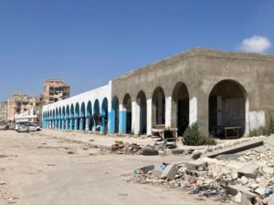
The old market of Benghazi. Photo Maria Luisa Palumbo
Visiting Benghazi with you, I got the impression that tribes are not only still a vital part of Libyan society, but they are also deeply inscribed into the space of the city, with neighborhoods related to different tribes… Did this socio-spatial structure affected the way the war unfolded? Was there a relationship between the front lines and the borders between different social clans?
I do not think this an accurate observation nor a precise characterization of Benghazi demography vis-à-vis topography. As someone who lives and has studied it closely, Benghazi is the only city in Libya that is a real mix of all sorts of Libyans and I do not recall one street dominated by one familial shade. Of course, there are exception like those villages that encircled greater Benghazi, but historically even the Jews of Benghazi, who left in 1967, never had a ghetto of their own like the way they did in Tripoli. Nonetheless, there are tribal lands in the countryside and there are sometimes disputes about them like the way that landlords would argue about the ownership elsewhere in the world.
In 2019, before the end of the war, the Greek LEAD Engineering was commissioned to prepare a conceptual Vision Plan for the future of the city, assessing major damage and proposing a framework for future planning. A revised and updated plan has been presented on June 17 following its approval by the Municipality of Benghazi. The plan includes a series of more detailed Action Plans for selected areas as well as a series of designs for immediate relief infrastructure projects and sample implementation plans for a number of spontaneous (unauthorized) housing areas. Can you tell me more about this plan?
The technical negotiations began years before 2019. In 2019, a government’s delegation headed by the Central Bank of Libya (CBL) governor (who was also the chairman of the Stabilization and Reconstruction Committee sat up by parliamentary decree), and including the city mayor and other notable civilian figures representing Benghazi’s business community, such as bankers, engineers, architects and other stakeholders, with no representation of the military what-so-ever, commissioned the plan. I was part of this delegation representing Salam Centre.
The plan deals with the urbanization of the city but also with the unauthorized housings and slums, with the environment, including the seven lakes, the sewage treatment and the project of mobility infrastructure capable to make the city to be a Viable and Smart Mediterranean city. The plan was presented to all the stakeholders and relevant authorities i.e., Urban Planning Agency, Land Registry, Housing Agency, the LNA and many others. The first positive and welcoming response was from the LNA.
Are the interventions done in the public housing neighborhoods of the 70s part of the immediate relief actions? And what about the Giuliana running track? Both looks as necessary and well received interventions…
As I understand from those involved in the execution of reconstruction “the skies are the limit” to modernizing the city. The poorer neighborhoods that were built in 1960/70/80’s are getting a facelift, and parks with amusements designated arcades for children to help overcome the war scars. For others for the first time there is standardized running track for those who wish to keep fit around the famous Giuliana Lake. Benghazi football arena is getting a completely new revamp. Also, they are constructing a record-6-bridges in the city to deal with increasing growing traffic congestions and subsequent pollution. Those should be completed by the end of 2023. As well, one must NOT forget the work going on to the mother of Libyan universities – Benghazi University – that suffered badly as documented by the Italian photographer, Giovanni Diffidenti, just after its liberation in 2018.
The School of Medical at Benghazi University. Photo Maria Luisa Palumbo
Another specific question has to do with the historic heritage. I know there has been criticism about the demolitions of what remained of the built heritage of the Italian colonial era. I see a difficult node there, not because of the demolitions per se, but because reconstruction in itself should probably require more collective discussion…
Absolutely, there should be a discussions and consultancy about critical matters such as this. However, there was a removal of very few momentous buildings which mostly were from the fascist architectural boom period from 1920’s up to WW2, and were badly hit during the recent “war on terror” like the Teatro Berenice and the Banca d’Italia, and others which were supposed to be demolished even prior to 2011 such the Assicurazione complex. There have been consistent and successful attempts by the city authority with the aid of United Nations Development Programme (UNDP) in Libya to renovate the Parlamento della Cirenaica, the Cattedrale di Bengasi, and part of the Palazzo del Governatore known as Qasr al-Manar, despite the hampering and freezing of money from the central authority of Tripoli.
The question that should be asked is why the central government of Tripoli, that has sat up a reconstruction fund for Benghazi and Derna with a budget of 1.5 billion Libyan Dinar, has only cashed 79 million after going through strenuous Tripoli-centric bureaucracy?
A last question about the plan. I understand that the scale of destruction and therefore the reconstruction aim is huge, and that there is a need to move quickly and to deal with the deep scars the war left on the city and its people, but what about the financial aspect of the project?
We in Benghazi have successfully and self-reliantly opened the first privately funded airport terminal (Berniq) as the first B.O.T [Build-operate-transfer, a project delivery method wherein a private entity receives a concession from the public sector] of its kind in the history of Libyan investment. Speaking of Berniq airline, this has the biggest fleet in Libya, even bigger than the national flag carriers, and flies to all Libyan ports unlike the others. Therefore, we must open up the region of Cyrenaica as a model for the rest of the country by welcoming investors and developers from all over the world. That should include the thinking of the sale of public assets, deregulation, opening up state monopolies to greater competition, contracting out, private provision of public services, joint capital projects using public and private finance, and reducing subsidies or introducing user charges. That in turn requires special legislation, banking reforms and internationally specialist & professional input from outside especially our neighbors such as our no.1 trading partner – Italy – and Egypt, Saudia Arabia, UAE, Greece and others.
On the occasion of my field research in Cyrenaica and presentation of my work on the intertwined histories of the agricultural colonization of Sicily and Libya at the Benghazi Salam Center on June 22, I interviewed the director of the center and Professor of Governance at the University of Benghazi Faraj Najem.
I’d like to begin this conversation trying to summarize the most important moments and reasons of the 2014 civil war, and I would like to do so precisely from the spatial location in which we find ourselves, that is, from the point of view of the city of Benghazi, from its representative buildings and urban areas. So, maybe a good starting point could be the Al Da’waa al-Islamiya building, in 2014 transformed from its original commercial function and turned into the new Libyan Parliament. In my understanding of the war, this “adaptive reuse” speaks about a nodal point in the conflict, that is, about Cyrenaica’s request of a spatial division or distribution of the executive and legislative powers between Tripoli and Benghazi, right? Is this division of powers between the two cities the core of Benghazi’s proposal of a federal unity between the two regions? Furthermore, Libya’s 1951 Constitution and 1963 Amended Constitution provided for two capitals, right?
This content if for our subscribers
Subscribe for 1 year and gain unlimited access to all content on
eastwest.eu plus both the digital and the hard copy of the geopolitical magazine